 EasyTicket
 At Hoeryongpo in Yecheon, the common approach is to walk the village first and climb to the lookout afterward, but if you want to avoid the crowds, going the other way around is far more comfortable. Head up to Hoeryongdae (Lookout No. 1) in the morning before the crowds arrive to take in the 350-degree river bend, then cross Ppyongppyong Bridge and walk down into the village — a reverse route.
Why Is It Better to Start at the Lookout?
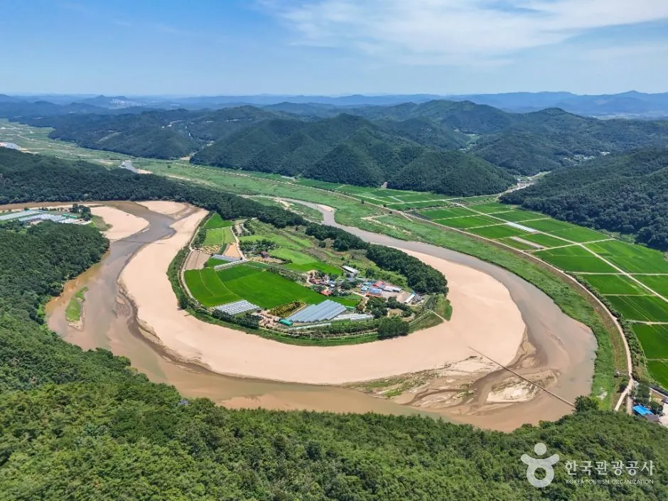
At Hoeryongpo, the Naeseongcheon Stream is blocked by a mountain and wraps almost completely around the village in a 350-degree bend (source: Korea Tourism Organization). This shape is completely invisible from inside the village — you can only take it in from Hoeryongdae, on the ridge of Biryongsan Mountain.
I laid out a map and tried the order a few different ways: if you walk the village first, you end up crossing the bridge, coming back, driving over toward Jangansa Temple, and then climbing the stairs — by which point there’s no energy left. Start the other way around, and you knock out the toughest climb while you’re still fresh.
| Segment | How to get there | Approx. time |
|---|---|---|
| Jangansa parking lot → Hoeryongdae | On foot, 223 steps | About 15 min |
| Hoeryongdae → Ppyongppyong Bridge entrance (by car) | Down the mountain toward the village | Drive |
| Ppyongppyong Bridge → Hoeryongpo Village | On foot | About 5 min |
| One loop of the village trail | 2.6 km on foot | Under 1 hr |
It’s easier not to take the walking trail that directly connects Hoeryongdae and the village. After seeing the lookout, the simplest route is to head back to the parking lot and drive to the entrance of Ppyongppyong Bridge.
How to Climb Up to Hoeryongdae — Starting from the Jangansa Parking Lot
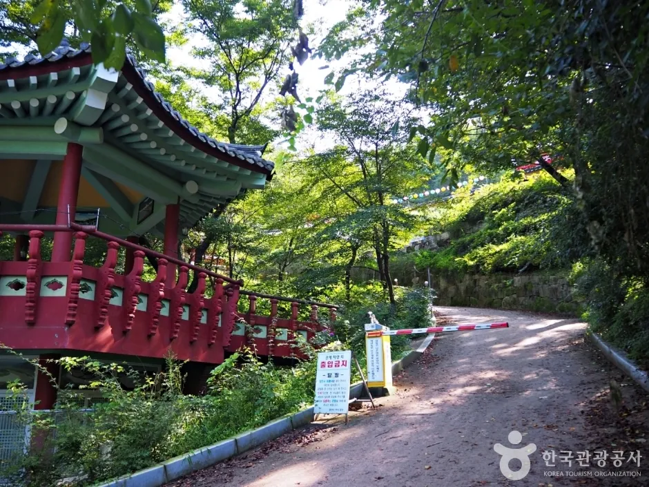
If you’re driving, your starting point is the free parking lot at the end of the paved road beside Jangansa Temple’s Iljumun Gate on Biryongsan Mountain. From there it’s on foot — climb the 223 steps behind Jangansa and you’ll reach Hoeryongdae. Biryongsan is only 240 meters above sea level, more of a hill than a mountain, but the final stretch of stairs is fairly steep.
If the Stairs Feel Like Too Much, Start with Lookout No. 2
Yongpodae, the second lookout that Yecheon County built on Biryongsan, is a gentle course reachable in about 10 minutes from the Sarimjae side. From Yongpodae, another 20-minute walk along the ridge gets you to Hoeryongdae, the first lookout. If anyone in your group is worried about their knees, this route is easier on them.
Crossing Ppyongppyong Bridge into the Village
Once you’re back down from the lookout, it’s time to enter the village you were just looking down on from above. The entrance for walking into Hoeryongpo Village is the first Ppyongppyong Bridge, at 347 Daeun-ri, Yonggung-myeon, Yecheon-gun, Gyeongbuk. It’s open at all times, free of charge, and there’s a parking lot at the bridge entrance.
The name has a fun backstory: the bridge is built from perforated steel plates like the kind used at construction sites, and when the water rises, it makes a bubbling sound through the holes. It used to be called “Pongpong Bridge,” and after the media introduced it as “Ppyongppyong Bridge,” that name stuck.
Ppyongppyong Bridge sits very close to the water’s surface. It can be closed off during the monsoon season or right after heavy rain, so if you’re visiting in summer, it’s safer to call ahead and check with the Hoeryongpo information center (054-650-6789) or the Yecheon County Culture & Tourism Division (054-650-6390) before you set out.
Hoeryongpo Village’s 2.6 km Loop Trail
The trail that circles the village is 2.6 km, and even at a slow pace it takes under an hour. Hoeryongpo is one of Yecheon’s Eight Scenic Views, and it’s an actual living community of 7 households and 12 residents (as of January 2024). Areas with yards, greenhouses, and farm equipment are private property, so think twice before pointing a camera at them. The rice grown in this village is sold under the name “Yonggung Jinsangmi” (literally “tribute rice from Yonggung”).
Add Samgangjumak to Complete the Trip
If you have time left, add Samgangjumak. Sitting where the Nakdong River, the Naeseongcheon Stream, and the Geumcheon Stream meet, it’s the last traditional jumak (roadside tavern) left in Korea. Built around 1900, it served as lodging for the peddlers and boatmen who once passed through the ferry crossing. A Chinese scholar tree more than 500 years old stands in front of the tavern.
The address is 53-23 Samgang-ri-gil, Pungyang-myeon, Yecheon-gun, Gyeongbuk, and the River Culture Exhibition Hall within the Samgang Cultural Complex on the same grounds is open 10:00–17:30 (until 17:00 in the winter months of November–March), closed every Monday. Fees and hours are subject to change, so a quick call to 054-650-6802 before you go can save you a wasted trip.
For a Quiet Visit, Just Remember This
- Start at Hoeryongdae in the morning — by late afternoon, backlighting makes the river bend look hazy
- The Jangansa parking lot has restrooms — use them before entering the village
- There’s no convenience store in the village, so pick up water at the parking lot shop beforehand
- The 2.6 km loop trail has little shade — bring a hat or parasol
- Call ahead to check whether Ppyongppyong Bridge is closed after heavy rain
- It’s a village where people actually live — please avoid drone footage and photographing yards
If you’re coming from Seoul by public transportation, the intercity bus to Yonggung takes about 2 hours 20 minutes and runs only 6 times a day, so if you’re going car-free, it’s more realistic to focus on Hoeryongpo alone.
Frequently Asked Questions (FAQ)
Can I walk down from Hoeryongdae straight to the village?
There is a mountain trail that connects them, but it requires heading back to the parking lot, which makes for a long round trip. If you have a car, it’s far simpler to see the lookout, head back to the parking lot, and drive to the Ppyongppyong Bridge entrance.
Can I cross Ppyongppyong Bridge any time?
It’s open at all times and free of charge. That said, it’s a low bridge that sits nearly flush with the water, so things change when water levels rise — during monsoon season, call the Yecheon County Culture & Tourism Division or the Hoeryongpo information line to check before you set out.
The 223 steps sound like a lot — is there another way?
You can first visit Yongpodae, the second lookout that’s just 10 minutes from Sarimjae, and if you have the energy, walk the ridge for 20 more minutes to reach Hoeryongdae. That said, Hoeryongdae still offers the best view of the river bend itself.
Are there restaurants or shops in the village?
Hoeryongpo is a small farming village of 7 households and 12 residents, so don’t expect much in the way of commercial facilities. Plan to eat near Samgangjumak or in the main part of Yonggung-myeon instead.
Just switching up the order — lookout → bridge → tavern — makes Hoeryongpo a far more relaxed place to visit. Clear the stairs early in the morning and spend the afternoon by the river; it’s a day that suits anyone looking for a quiet getaway.
Image credits6
- 📷 김재현 / 한국관광공사 포토코리아 (공공누리 출처표시)
- 📷 김지호 / 한국관광공사 포토코리아 (공공누리 출처표시)
- 📷 Regi Munandar / Unsplash
- 장안사(예천) (2) - 한국관광공사 (출처표시+변경금지)
- 예천_회룡포 (3) - 한국관광공사 (출처표시)
- 대표 이미지 - 한국관광공사 (출처표시)